amblenorthumberland
We are proud to be
Gold Award
Northumberland Tourism Ambassadors!

HISTORY & HERITAGE OF AMBLE
Click here to read about the Development of Amble
Early Origins
Amble was originally located well to the south of the mouth of the River Coquet,
however in March 1764, the river below Warkworth changed its course due to
heavy rain. The river sought its most direct route to the sea and broke its banks
across a broad meander and as a consequence Amble found itself less than one
third of a mile from the new river mouth. This event changed the fortunes of
Amble.
Today Amble lies at the mouth of the River Coquet on the North Sea coast in mid-
Northumberland. It is located nine miles south of Alnwick and a mile southeast of
Warkworth. The town was built on a peninsula, providing extensive views of the
surrounding coastline.
There are two theories where the name Amble comes from – one is that it is
thought to have derived from Annebelle, an Old English term meaning ‘Anna’s
Promontory’, however Prof Paul Younger of Newcastle University favours a Gaelic
origin from "Am Béal", meaning "the river mouth". Amble and the surrounding
area has been populated for many centuries. Ancient British grounds, have been
found here as well as Roman coins at Gloster Hill, signifying occupation during
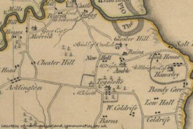
different periods of time. (Map below courtesy of
communities.northumberland.co.uk)


The earliest mention of ‘Ambell’ can be found in 1090
when, after the division of the spoils, the manors of
‘Ambell’ were amongst other grants of land given to
the Tynemouth Priory by the powerful noble Robert
de Mowbray. After the dissolution of the monasteries
in 1536, the land of ‘Ambell’ became the property of
the king.
In 1204 the spelling used was Ambell’ and by 1610,
‘Speeds Map’ used the name Anbell’. However by 1769
‘Armstrong’s Map’ was using the modern spelling of
Amble. The name Amble is generally accepted to
mean ‘Anna’s Bill’ or ‘Anna’s Promontory’ – however no
one is quite sure who Anna was!
For a short time in the 1980’s Amble was officially known as Amble-by-the-Sea, however this was dropped in
1985 and the town reverted back to being called Amble (although the Parish is still called Amble by the Sea).
Amble also holds the title 'Kindliest Port' or ‘Friendliest Port’. It is believed that this comes from the 1930s when
the RMS Mauretania was heading on her last voyage to the breaker's yard at Rosyth in Scotland. Some say the
ship stopped for the last time in Amble. However another version of the story is that Amble Town Council
(Amble Urban District Council) sent a telegram to the ship saying "still the finest ship on the seas" and the
Mauretania replied with greetings "to the last and kindliest port in England" Over time, this response has been
altered to say The Friendliest Port!
The earliest recorded reference to Gloster Hill in a twelfth century charter. It records Roger fitz Richard, the
baron of Warkworth who died in 1178, granting saltworks to the Abbot and convent of Newminster, a Cistercian
abbey founded in 1137 near Morpeth.
The salt pans were located between Gloster Hill and the bottom of the Wynd. Initially salt was made by burning
wood, but this resource soon became scarce. It then became a necessity to use coal, of which there was plenty of
stock. A large amount of pit shafts were located between the harbour and neighbouring Hauxley. The mining
around this area was primarily for the salt industry. Records of 1611 indicate that small-scale coalmining and
salt-making were common activities close to Amble and particularly towards the coast at Pans Point hence the
name. Much of the salt was used as a preservative in the local fishing industry. Salt making in this area finally
ceased in 1927.
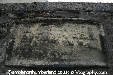
The oldest part of Amble is the area at the top of the
Wynd centred round an area called ‘Togston Square’
which no longer exists except for aweathered stone
plaque. The Wellwood Arms pub is one of the oldest
buildings in Amble and was originally a farmhouse for
Link House Farm – one of the three farms, which made
up early Amble (when the population was a mere 152).
The 1842 Tithe records for Amble shows that Link
House Farm and surrounding land was owned by a
Mrs Maria Wellwood – which may be one explanation
for the name The Wellwood Arms. Another
explanation is that the original farmhouse was served
by the Hallbank Well, which was located in woods
nearby.

Definite seventeenth century remains in Amble can be seen at Gloster Hill (which is located on a hill to the left
of Amble going north. Hidden behind a hedge to the east of Gloster Hill Farmhouse are the remains of the old
gate piers which mark the main entrance into a substantial seventeenth century house which was partially
destroyed by fire in 1759 and finally demolished in 1938 to make way for the current farmhouse.
According to sources in 1066, the manor of Amble was given to the Duke of Northumberland in recognition of
his support in the Battle of Hastings. He, in turn, donated some of the land to Tynemouth Priory. The monks
built a Manor House or Grange overlooking the Coquet River which enabled them to levy tolls on in-coming
boats which usually anchored just below this point. A Grange was a country house with productive farm
buildings attached.
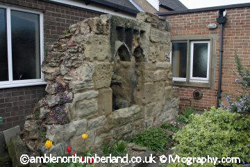
Today all that remains after the dissolution of the
monasteries in the 16th century is a part of the
wall of the Monastic Manor House is a remnant
of an arched window and lights. The wall fragment
is fifteenth century, is set at right-angles to the
escarpment above the Braid and measures 4m
in length and a maximum of 2m high. It is about
1m thick, made up of roughly dressed inside and
outside stones with a rubble stone filling between.
It also contains a decorative window of two lights
which faces toward the west. This can be seen in the small Calvary garden to the side of the Catholic church.
Excavation in 1897 indicated that this was the wall of a service wing which adjoined the hall which lay to the
west.
On a terrace below the manor house ruins is the medieval Hallbank Well. Although the well is of medieval
origin, the exposed part is from the eighteenth and nineteenth centuries. The well system now contains a
partly-subterranean cistern and the remains of a flushing tank. Hallbank Well (to the right and down the rise
and path from the Sacred Heart Church) was described in early manuscripts as ‘a spring of sweet water’ and
was the original water supply for Amble at the time when the Benedictine Monastery stood on the site of the
Manor House. An underground reservoir was added in Victorian times to provide fresh water for the growing
population. Unfortunately at the present time Hallbank Well is hidden by dense undergrowth.
Early Industry
Amble owes much of its growth and early prosperity to the 19th century coalfields from which it used to ship
coal to southern England and the Continent. As collieries were opened; Amble’s location at the mouth of the
River Coquet, and its railway links to the Northumberland coalfields, made it a centre for the transportation
and export of coal. Today, the collieries in Northumberland are all closed (the last, Ellington, closed in 2005),
and the railway no longer serves Amble.
Other industries, such as ship building and repair, and sea fishing, expanded with the growth of the town,
although traditional Northumbrian fishing vessels such as cobles have sheltered in the natural harbour here
for many centuries previously.
To the north of the town, along the riverside land known as The Braid was originally the site of a shipyard. Boat
building began in Amble at the end of the 18th century when the ‘Chevington Oak’ was built with wood from
nearby Chevington Woods. There was also a joinery yard and sawmill on the Braid on the site where the
Marina Arms now stands.
Later Concrete vessels were built in the shipyard to replace ships lost during WWI but the venture failed
as the technology was not sufficiently advanced.
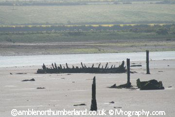
A survey carried out by English Heritage examined
aerial images in the estuary of the River Coquet
adjacent to the Braid and discovered four unknown
shipwrecks on mudflats near Amble. Although the
existence of these wrecks was known, their exact l
ocation has until now been unrecorded. At low tide
many of these shipwrecks can be clearly seen from
the Braid.
The 1897 OS map recorded further changes in Amble as it became more industrialised. All parts of the town
had been extended, except for Gloster Hill which had stood still. Old Amble had filled out with development
along the north side of High Street including a new Methodist chapel because the old one had become a
school and there had been the creation of a new street (Bede Street) to the south of Amble House with new
terraces and a Congregational Church.
Queen Street had doubled in length and was now completely built up on both sides for the whole of its length.
A parish church (in 1870) and a church school had opened up between Queen Street and Church Street and a
Rectory had been built in its own grounds opposite the church. There was still some undeveloped land
between the end of Queen Street and the harbour but there is evidence of terraces being built from both sides
of the vacant area.
The harbour had a brickworks, boatyards, and an extensive network of high-level railway lines serving timber
coal staithes around the harbour at the Radcliffe and Broomhill Quays. The town’s railway station was built in
1878 and was approached by a sloping ramp from Church Street. A station hotel was also built close by (now
known as Fourways Centre)
To the south, more fingers of terraces reached out to fill the area between the branch railway line, the old
settlement and Queen Street. Finally, more stone terraces were developed in a group immediately south of the
harbour. There is no evidence of any development at all beyond the north escarpment of the town except for
allotment gardens.
By 1920, the space between the old town and the branch line was filled by stone terraces and allotments, and
development was almost continuous between the harbour and Queen Street. Fingers of stone and brick
terraces were for the first time, being built at the west end of the town. The regular rail passenger service was
still in use but it would close within ten years; the last passenger excursion from Amble to Newcastle took
place in 1939 and by 1969, the branch line closed completely. Development was also appearing on the Braid
but still close to the steep escarpment behind the High Street.
Today, Amble is Northumberland's most important fishing centre north of the River Tyne. The fishing industry
survives, although it has reduced numbers of vessels now, as does a small marine industry - mainly
concentrated around the construction and repair of yachts and other pleasure craft. Leisure sailing has also
become important and, as well as the marina, the town has a vibrant yacht and boat club. A small industrial
estate is located to the southwest of the town.. Amble also has a number of good shops including Tesco and
Boots, gift shops, and many restaurants, pubs and fast food outlets. Tourism now forms an important sector of
Amble’s economy and there are several caravan parks, guest houses and B&Bs as well as many holiday
cottages in the town catering for the numerous visitors who come to the Northumberland coast every year.


